Transfăgărășan High Road Loop
Cross from Curtea de Argeș and Lake Vidraru to Bâlea and Sibiu on a seasonal four- or five-day mountain circuit.
- Allow
- 4–5 days
- Route
- 642 km
- Drive time
- 9 hr 45 min
- Stops
- 6
The DN7C climbs from Wallachia past Curtea de Argeș and Vidraru into the Făgăraș, crossing near Bâlea Lake before dropping toward Sibiu. The engineering is spectacular, but the route is also slow, exposed and frequently stopped by weather, traffic, sheep and people photographing bears from unsafe positions.
The high section is seasonal and its opening dates are not a promise for every hour of the day. Check the national road authority’s live status, keep a full-day alternative and never feed or approach bears. If the pass is closed, visit the southern valley or reach Sibiu by the all-season route instead.
The road, in one glance
Pinch or scroll with Ctrl / ⌘ to zoom
Drawing the route…
The route earns
its distance
Each pin is selected as a place to do something—not merely proof that you passed through.
 Photo: Madalin Pentelie · CC0
Bucharest
Leave early with the live pass status checked and a lower-road alternative already accepted.
Bucharest (Romanian: București ) is the capital and largest city of Romania. The metropolis stands on the River Dâmbovița in south-eastern Romania. Its population is officially estimated at 1.71 million residents within a greater metropolitan area of 2.31 million residents, which makes Bucharest the 9th most-populous city by population within city limits in the European Union.
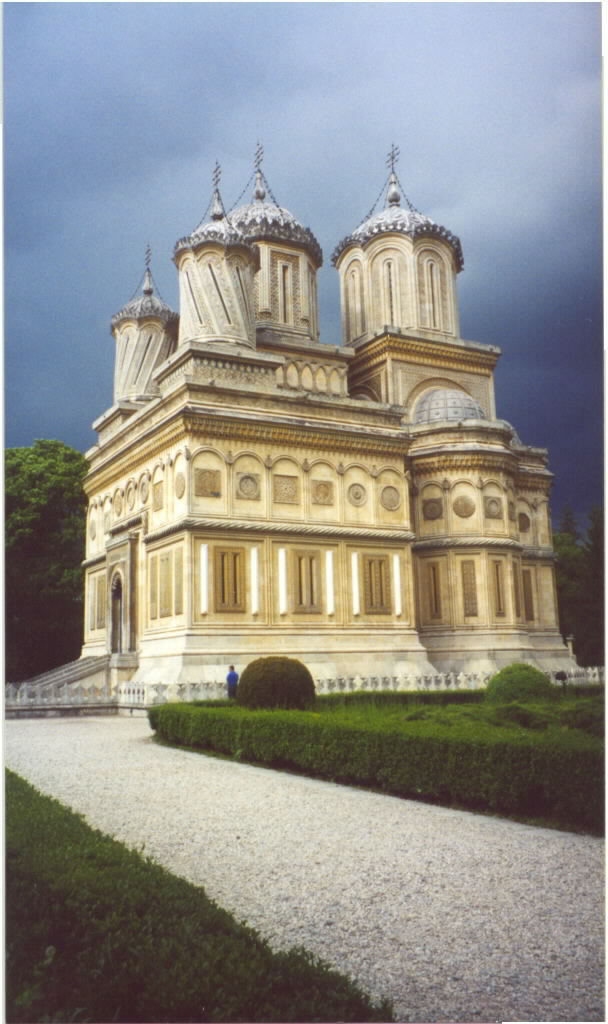 Photo: Lawson Speedway · Public domain
Curtea de Argeș
A former Wallachian capital and ornate monastery establish the historical southern gateway to the mountains.
Curtea de Argeș is a city in Romania on the left bank of the river Argeș, where it flows through a valley of the Southern Carpathians (the Făgăraș Mountains), on the railway from Pitești to the Turnu Roșu Pass. It is part of Argeș County. The city also administers one village, Noapteș.
 Photo: Cristian Bortes · CC BY 2.0
Vidraru Dam
A high concrete dam and long reservoir lead into increasingly wild Făgăraș scenery.
Lake Vidraru (Romanian: Lacul Vidraru) is an artificial lake in Romania. It was created in 1965 by the construction of the Vidraru Dam on the Argeș River. It lies in the shadow of the Făgăraș Mountains.
 Photo: Wikimedia Commons contributor · CC BY-SA 3.0
Bâlea Lake
A glacial lake near the road’s highest tunnel sits amid open alpine slopes and abrupt weather.
Bâlea Lake is a glacier lake situated at an altitude of 2,034 m (6,673 ft) in the Făgăraș Mountains, in central Romania, near Cârțișoara, Sibiu County. There are two chalets opened all year round, a meteorological station, and a mountain rescue (Salvamont) station. The lake is accessible by car via the Transfăgărășan road during the summer, and the rest of the year, access is provided by a cable car from the "Bâlea Cascadă" chalet.
 Photo: Andrei Dan Suciu · CC BY 3.0
Cârța Abbey
Cistercian ruins in the northern foothills make a quiet architectural counterpoint after the pass.
The Cârța Monastery (Romanian: ) is a former Cistercian (Benedictine) monastery in the Țara Făgărașului region in southern Transylvania in Romania, currently an Evangelical Lutheran church belonging to the local Saxon community. It lies on the left bank of the Olt River, between the cities of Sibiu and Făgăraș, close to the villages of Cârța (German Kerz, Hungarian: Kerc) and Cârțișoara (German: Kleinkerz).
 Photo: Zubi Travel · Public domain
Sibiu
A two-night stay in the Saxon city turns the crossing into a journey rather than an endurance drive.
Sibiu is a city in central Romania, situated in the historical region of Transylvania. Located some 275 km (171 mi) north-west of Bucharest, the city straddles the Cibin River, a tributary of the Olt River. Now the seat of Sibiu County, between 1692 and 1791 and 1849–65, Sibiu was the capital of the Principality of Transylvania.
Drive the conditions,
not the itinerary.
Verify the DN7C live status with the road authority on the day. Never approach or feed bears, stop only in marked areas and descend in a low gear.
Checked against
the people who run it
Distances and driving times are planning estimates. Conditions, closures, ferries, permits and park rules can change, so check the linked official guidance before setting out.